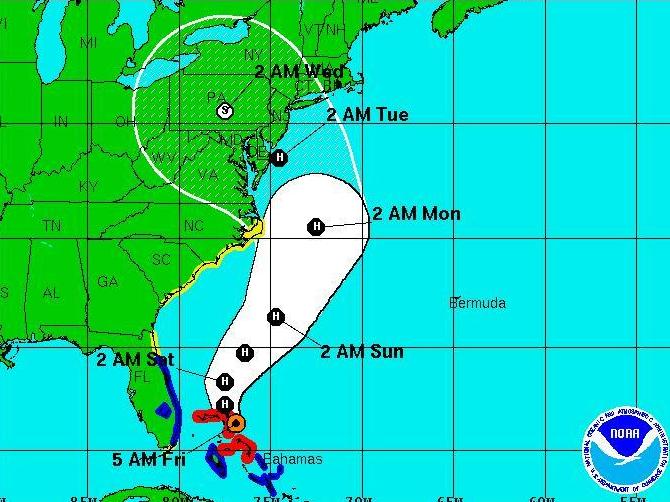
Hurricane Sandy's projected track, as of 5 a.m. today.
Hurricane Sandy's projected track, as of 5 a.m. today.
National Hurricane Center"We're not trying to hype it," National Weather Service meterologist Paul Kocin tells Bloomberg News. "What we're seeing in some of our models is a storm at an intensity that we have not seen in this part of the country in the past century."
So get ready, mid-Atlantic states, the Northeast and New England: Hurricane Sandy, which has already caused at least 21 deaths in the Caribbean, is still on track to turn toward you on Monday. And if that happens, it will meet up with a winter storm coming from the West and cold air coming down from Canada to become what could be a horrible "Frankenstorm" (Halloween is Wednesday).
Oh, and there's also a full moon on Monday. As that affects tides, the concern about storm surges along coastal areas grows.
The Federal Emergency Management Agency is warning folks from Florida to New England to "update your family communication plans, check your supplies, and stay informed."
The storm that Kocin and some other meteorologists are saying this could rival was a 1938 hurricane that hit Long Island and New England hard â€" more than 500 people were killed, Bloomberg notes.
At 5 a.m. ET today, Sandy was about 485 miles southeast of Charleston, S.C. The National Hurricane Center's latest "5-day forecast cone" shows Sandy grazing the coast of North Carolina around 2 a.m. ET on Monday, then turning to the northwest and making landfall around Delaware at 2 a.m. ET on Tuesday. It would then head across the mid-Atlantic and toward the Great Lakes.


